The Oxford American Dictionary defines geometry as "the branch of mathematics dealing with the properties of and relations of lines, angles, surfaces and solids." On August 11, 1997, the Open GIS Consortium Inc. (OGC) in its publication, Open GIS Features for ODBC (SQL) Implementation Specification, coined another definition for the term. The word geometry was selected to denote the geometric features that, for the past millennium or more, cartographers have used to map the world. A very abstract definition of this new meaning of geometry might be "a point or aggregate of points symbolizing a feature on the ground."
In DB2 Spatial Extender, an operational definition of geometry might be "a model of a geographic feature." The model can be expressed in terms of the feature's coordinates and also, in some cases, in terms of a visual symbol. The model conveys information; for example, the coordinates identify the position of the feature with respect to fixed points of reference, and the symbol outlines its form. Also, the model can be used to produce information; for example, the ST_Overlaps function can take the coordinates of two proximate regions as input and return information as to whether the regions overlap or not.
The coordinates of a feature that a geometry symbolizes are regarded as properties of the geometry. Several kinds of geometries have other properties as well; for example:
These and additional properties are discussed in Properties of geometries and associated functions.
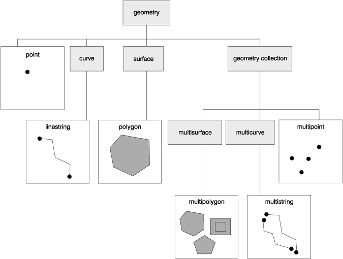
The geometries supported by DB2 Spatial Extender form a hierarchy, shown in Figure 9. Six members of the hierarchy are instantiable; they can be expressed as visual symbols, which are also shown in the figure.
Figure 9. Hierarchy of geometries supported by DB2 Spatial Extender. Instantiable geometries can be expressed as visual symbols. These symbols are shown under the names of these geometries.
 |
As Figure 9 indicates, a superclass called geometry is the root of the hierarchy. The subclasses are divided into two categories: the base geometry subclasses, and the homogeneous collection subclasses. The base geometries include:
The homogeneous collections include:
As their names imply, the homogeneous collections are collections of base geometries. In addition to sharing base geometry properties, homogeneous collections have some of their own properties as well.
The spatial data types supported by DB2 Spatial Extender are implementations of the geometries shown in Figure 9. For a description of these data types, see About spatial data types.