ST_Overlaps takes two geometry objects and returns 1 (TRUE) if the intersection of the objects results in a geometry object of the same dimension but not equal to either source objects; otherwise it returns 0 (FALSE).
Syntax
db2gse.ST_Overlaps(g1 db2gse.ST_Geometry, g2 db2gse.ST_Geometry)
Return type
Integer
Examples
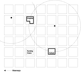
The county supervisor needs a list of hazardous waste sites whose five-mile radius overlaps sensitive areas.
The following CREATE TABLE statement creates the SENSITIVE_AREAS table. The SENSITIVE_AREAS table contains several columns that describe the threatened institutions in addition to the ZONE column, which stores the institution's polygon geometry.
CREATE TABLE SENSITIVE_AREAS (id        integer,
                              name      varchar(128),
                              size      float,
                              type      varchar(10),
                              zone      db2gse.ST_Polygon);
The HAZARDOUS_SITES table stores the identity of the sites in the SITE_ID and NAME columns, while the actual geographic location of each site is stored in the LOCATION point column.
CREATE TABLE HAZARDOUS_SITES (site_id   integer,
                              name      varchar(128),
                              location  db2gse.ST_Point);
In the following SELECT statement, the SENSITIVE_AREAS and HAZARDOUS_SITES tables are joined by the ST_Overlaps function. It returns 1 (TRUE) for all rows in the SENSITIVE_AREAS table whose zone polygons overlap the buffered five-mile radius of the HAZARDOUS_SITES location point.
SELECT hs.name
FROM HAZARDOUS_SITES hs, SENSITIVE_AREAS sa
WHERE db2gse.ST_Overlaps (buffer(hs.location,(5 * 5280)),sa.zone) = 1;
In Figure 37, the hospital and the school overlap the five-mile radius of the county's two hazardous waste sites, while the nursing home does not.
|